Everything begins here – on the waterways
The wetlands that the Millennium Trail traverses are part of a watershed that begins east and south of here. The stream, originally named Dorland’s Creek, is 9.8 km in length, and flows in a westerly direction eventually emptying into Pleasant Bay. Two marshes in its course spread out over flat land. This stream was, in days gone past, impressive, fast flowing and high in spring, ice-covered and slow moving in winter.
Ancient settlements, dating as far back as 5,000 years ago were the first villages by the stream and artifacts from these early inhabitants have been found in the surrounding fields. Centuries later, circa 1000 – 1300, an Iroquoian village was established. These were the first farmers, growing corn, tobacco, beans and squash to supplement hunting and fishing. The village may have had a group of eight rectangular longhouses made of bent saplings covered with bark. Each one would have been more than a hundred feet long, housing six to ten families. These were situated in a clearing between the thickly wooded swamp and the stream, behind the bluff of land, so as to be safe and not easily seen from the great lake.
By the 17th century it is recorded that this area was a no man’s land, inhospitable, and dangerous. To the south of Lake Ontario, the Iroquois laid claim and to the north, the Huron. The County, thrust out into the lake was an unfriendly and often uninhabited land, dense with trees.
In 1783, at the end of the American Revolution, Britain signed a treaty giving up the American colonies. This prompted the Crawford purchase of 1783 and the lands of Prince Edward County came under the British crown.
The land in this area, named Pleasant Valley, was first deeded to Joseph Forsyth on August 4th, 1795. He resided in Kingston and worked for a company that distributed supplies on behalf of the crown to the refugees. His grant of land was 1200 acres, fronting Lake Ontario and extending back in a wedge shape over three concessions. Roads were little used by the original settlers as they were often undeveloped or in poor repair. The County was therefore laid out as a patchwork of land grants, with a need to front all lots on water to ensure transportation of people and supplies.
Forsyth did not live here but leased the land to Joseph Dorland, a Quaker who built a saw mill (circa 1802), located just north of what is, now, Highway 33. The mill encouraged settlement since people could now build houses and barns. In 1820, Forsyth’s estate sold some of the land, the mill and town sites, to Dorland.
A by-product of a lumber mill is ash so the next step was to set up a kiln on the creek and make potash. This potash was used in the making of glass, dye and soap, perhaps the first man made exports from this region. A grist mill was built in 1811, situated to use the flow of this water as it entered into Pleasant Bay. A millstone of pink granite from this mill can be seen in Taylor Park, just a few steps away on Station Rd. The mill operated only a few months of the year because of ice and low water, but the local settlers no longer had to make treacherous trips to distant mills. A cooperage followed making barrels to hold and transport the flour.
In 1816 a tannery was established to produce leather. The creek provided plenty of water for washing the hides and for tanning solutions. The success of this enterprise begat the Foster Inn and stage shop. A post office, school and a plaster mill were added to this small settlement.
Pleasant Valley was in the centre of the new township, thus becoming the municipal hub. Major George Hillier, private secretary to the Governor General, arrived in Canada in 1818. The township was named in his honour, as was the Post Office which opened in 1825. This was only the second post office in Prince Edward County. It was noted that an English travel map named only Hillier from Newcastle to Bath.
Further upstream, Trumpour’s saw mill was built. The remnants of that dam are now part of Closson Rd. Dorland’s Creek eventually came to be known as Slab Creek, named for the slabs of wood that floated down the stream from that mill.
A final mill, for carding and fulling raw wool to processed wool cloth, was added to this creek in late 1830s. At least one weaver moved to the village. The carding mill was the last of the pioneer water-powered mills to be built on the creek and necessitated the building of a new dam, situated mid-way between the grist mill and the original saw mill.
1867: The Confederation of Canada
Three provinces, Nova Scotia, New Brunswick and the Province of Canada (which would become Ontario and Quebec) came together as one Dominion with the signing of the British North America Act. Prince Edward County became a federal electoral district. A new country with unlimited opportunities was underway.
The local council began an ambitious new project and on February 6, 1867 passed a by-law to purchase a site and erect a Town Hall at Pleasant Valley. The hall built of roughly squared stone quarried from a nearby lot was completed at a cost of fourteen hundred dollars. Hillier Town Hall opened in 1869.
In 1871, the saw mill, now no longer viable, was repurposed for cheese-making.
Eventually this was linked to a butter factory in Niles Corners, just to the south, and the Cloverdale Butter and Cheese Manufacturing Factory came into operation. A handmade plaque to honour this factory is here in this kiosk.
In 1874 a carriage factory that incorporated a wagon-making shop was built. The new building was a two story board and batten frame structure eighty feet long by twenty-four feet wide. This building was purposely built to span the creek. It also fronted onto what is now Highway 33, so as to have easy access to the road and is seen in the accompanying photo. A large building was needed to accommodate carriages, buggies, wagons and sleighs. Such a business used many trades including iron workers, lathe operators for spoke-making, upholsters and painters in a dust-free paint shop. It was a thriving landmark.
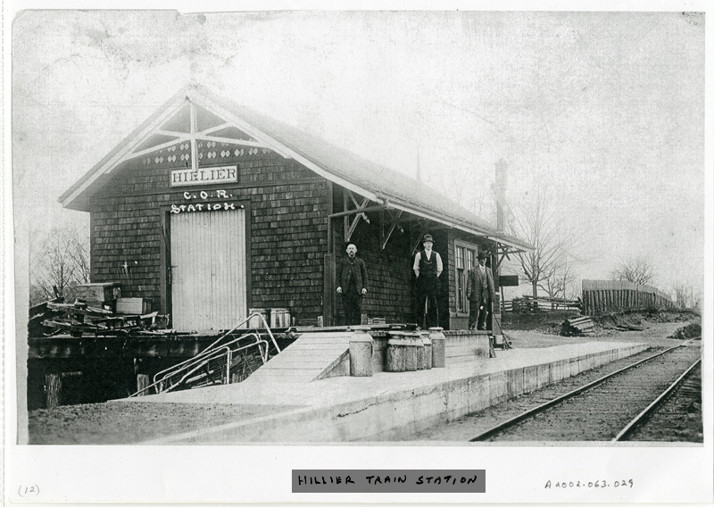
In 1879, the railway was completed. The enterprise consisted of two wood-burning locomotives, the Trenton and the Picton, two coaches, two baggage cars and two flat cars. As tracks were laid to avoid hills the line and station were a short distance from the village. Mail was brought from the post office to the train station daily by a hand cart. You can see the station in the accompanying picture. It was located on the opposite side of the Trail, and if you look you will see the concrete foundation.
In 1898 the carriage factory closed but the building was repurposed for a new thriving industry, the export of dried fruit. Again, dependent on the creek, the MacDonald Evaporator opened, supporting the many local apple orchards and providing seasonal employment. Buildings were often moved and repurposed and one of the last mills became the Crippen cider mill, another highly successful enterprise.
In 1923 the Wellington Consolidated School opened its doors. Local students, after completing eighth grade, could ride the train to Wellington to attend high school. Parents were responsible for the cost of high school. With a book of train tickets that lasted a month and cost three dollars, a student could take the train to Wellington which offered courses to Grade 12. For Grade 13, students would ride to Picton. It was reported that arrivals and departures at school had to be flexible to meet train schedules.
Travel by train was not without incidents. The track through this area was considered to be hazardous, as the marsh would flood in the spring. In 1922, further south along this track, there was a washout. The engine stayed on the track but the coaches overturned and were dragged one hundred yards leaving the passenger coach on its side in three feet of water. Forty-five passengers escaped through the windows.
On November 25, 1927 students waited alongside this track for the train to take them to school. Just as the engine reached the students there was a terrific boom. The fire box on the train exploded, spewing steam and red hot cinders on everyone. Numerous students were badly burned, and were taken to the Young household, just around the corner. Dr. Robertson was called from Wellington and came to provide medical care. Thankfully, no one died in this accident.
By 1900, the old water powered mills on the creek were closed but the railway was a boon to the new industry of canning. The Bloomfield Packing Company built the immense canning factory next to this location in 1907. By 1910 it had become the Hillier Preserving Company. The principal product was canned tomatoes, using the labels “Quaker” and “Puritan”. In 2021, the distinctive building that you see is part of a poultry processing operation. Again, a building is repurposed.
Another highly successful canning factory was also located on the banks of this creek. Pleasant Valley Canners was owned by Jack Taylor and operated seasonally for over twenty-five years until 1978, employing as many as seventy five people each year.
In 1981 the County purchased the land and building, repurposed this factory building into the Township Fire Hall (now closed) and created a park. The Jack Taylor Centennial Park, with playground, gazebo and ball diamond is just a short stroll away. Fittingly, this park is on part of the 140 acre farm originally owned by Joseph Dorland.
The stream is now much diminished. The once prosperous and historic industries no longer rely on the surge of current for power, but the water still flows through this valley to Pleasant Bay and into the great lake. Through the many changes over thousands of years, the marsh remains as it has.
Credit for this historical information: Edith Dorland Taylor Ashton (1914-2005). On the edge of history: Dorland’s Creek and the mills by E.D. Taylor Ashton. Hermitage Publishing Corporation, Ottawa 1996